Big Timber, Mt. heading for natural bridge / Box Canyon today. Bear country.
Dead end road goes down between absoroka & beartooth mtns. May be there thru Jul
4th weekend.
Up early.
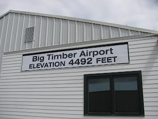
Headed into Big Timber for supplies and to possibly get a map of Box canyon from the Gallatin National Forest Ranger station. State road map was ok, but not very detailed. Close to town theres the local airport sign w/ arrow pointing to the next turn west. So let's go check out the Big Timber airstrip. As a pilot I always like to see the local airstrips/ fields, any planes, tie downs, ect... Let's just check out the field.
Stopped at airport on way into town & met Jason, USMC, a fine young man/ pilot & his local view helped steer the days
course. Ranger Lady at Gallatin Nat Forest service had route map & (and Marine Son also); station/ camp
listings of Box Canyon.. what was really needed. & advice (Bear Warnings) on going into this
Montana wilderness. One reason I really loved serving the country in the Marine Corps is... Marines really do look out for each other. Forever !
Hwy 298 S down past McLeod, MT -- a tiny place - 2 stores.
... & believe me THIS was THE last civilization for the next 48 miles to the end
of the Canyon.
Valley w/ Boulder river is beautiful. A few Montana ranches/ hay/ cattle/ horses. Natural Bridge
Falls... spectacular. Another river that sinks into a limestone sink & comes up
--- this time 200 yds away. Waded in the shallows & then drove on into the canyon.
Then go into canyon gap & it's dirt roads . 10mph is fast & will shake teeth.
potholes... Slow to 5mph & even creep over rocks/ potholes in places. Toweering mountains each side W/ Snowpack. Absoroka west mt Cowan 11,206 /
Beartooth East mt Douglas 11,298't... both rising 1,000 to 1,500 ' w/ some
snopwcaps along canyon . Boulder River is fast from snowmelt. sometimes 2-4 ft
from dirt road edge.
Road is single lane most of the way down Box canyon.
Snowpacktime. ... & bumpy... Pronghorn Elk, deer, mule deer along the way. few
cabins
Boulder river is whitecaps most of time in places. Fast flowing now. Over banks of river in places. Stop
at chippy park camp for night. mule deer & faun/ doe 50 yds away grazing. Burn any trace of
garbage. Bear country & warnings of food storage. Metal Food bins here. rain sprinkles.
***


Wed Jun 30, 2010 Pre Box canyon Gear up
Big Timber, Mt. heading for natural bridge / Box Canyon today. Bear country.
Dead end road goes down between absoroka & beartooth mtns. May be there thru Jul
4th weekend.
Up early.
Headed into Big Timber for supplies and to possibly get a map of Box canyon from the Gallatin National Forest Ranger station. State road map was ok, but not very detailed. Close to town theres the local airport sign w/ arrow pointing to the next turn west. So let's go check out the Big Timber airstrip. As a pilot I always like to see the local airstrips/ fields, any planes, tie downs, ect... Let's just check out the field.
Stopped at airport on way into town & met Jason, USMC, a fine young man/ pilot & his local view helped steer the days
course. Ranger Lady at Gallatin Nat Forest service had route map & (and Marine Son also); station/ camp
listings of Box Canyon.. what was really needed. & advice (Bear Warnings) on going into this
Montana wilderness. One reason I really loved serving the country in the Marine Corps is... Marines really do look out for each other. Forever !
Hwy 298 S down past McLeod, MT -- a tiny place - 2 stores.
... & believe me THIS was THE last civilization for the next 48 miles to the end
of the Canyon.
Valley w/ Boulder river is beautiful. A few Montana ranches/ hay/ cattle/ horses. Natural Bridge
Falls... spectacular. Another river that sinks into a limestone sink & comes up
--- this time 200 yds away. Waded in the shallows & then drove on into the canyon.
Then go into canyon gap & it's dirt roads . 10mph is fast & will shake teeth.
potholes... Slow to 5mph & even creep over rocks/ potholes in places. Toweering mountains each side W/ Snowpack. Absoroka west mt Cowan 11,206 /
Beartooth East mt Douglas 11,298't... both rising 1,000 to 1,500 ' w/ some
snopwcaps along canyon . Boulder River is fast from snowmelt. sometimes 2-4 ft
from dirt road edge.
Road is single lane most of the way down Box canyon.
Snowpacktime. ... & bumpy... Pronghorn Elk, deer, mule deer along the way. few
cabins
Boulder river is whitecaps most of time in places. Fast flowing now. Over banks of river in places. Stop
at chippy park camp for night. mule deer & faun/ doe 50 yds away grazing. Burn any trace of
garbage. Bear country & warnings of food storage. Metal Food bins here. rain sprinkles.
***